• HOME
  • DONEGAL
    • DONEGAL FACTS
    • Towns & Villages of Donegal
    • Donegal ISLANDS
    • DONEGAL CHURCHES & GRAVEYARDS
    • HISTORICAL DONEGAL
    • SCHOOLS National
    • DONEGAL MASS ROCKS
    • FAMINE PLACES DONEGAL
    • OLD POSTCARDS OF DONEGAL
    • THINGS TO DO IN DONEGAL
  • BLOG
  • MORE
    • IRISH SONG WORDS
    • ALL THINGS IRISH
    • IRISH BABY NAMES
    • GALLERY
    • WW1 & WW2 GRAVES IN DONEGAL
    • LINKS
    • CONTACT
  • HOLY WELLS OF DONEGAL
    • Bruckless St. Conall's
    • Doochary St. Sarah's Well
    • FANAD Carryblagh St. Colmcilles Well
    • INISHOWEN Grianan St. Patrick's Well
  • DONEGAL VIDEOS
We Love Donegal
  • HOME
  • DONEGAL
    • DONEGAL FACTS
    • Towns & Villages of Donegal
    • Donegal ISLANDS
    • DONEGAL CHURCHES & GRAVEYARDS
    • HISTORICAL DONEGAL
    • SCHOOLS National
    • DONEGAL MASS ROCKS
    • FAMINE PLACES DONEGAL
    • OLD POSTCARDS OF DONEGAL
    • THINGS TO DO IN DONEGAL
  • BLOG
  • MORE
    • IRISH SONG WORDS
    • ALL THINGS IRISH
    • IRISH BABY NAMES
    • GALLERY
    • WW1 & WW2 GRAVES IN DONEGAL
    • LINKS
    • CONTACT
  • HOLY WELLS OF DONEGAL
    • Bruckless St. Conall's
    • Doochary St. Sarah's Well
    • FANAD Carryblagh St. Colmcilles Well
    • INISHOWEN Grianan St. Patrick's Well
  • DONEGAL VIDEOS

CLONDAHORKEY OLD CHURCH AND GRAVEYARD, Kill, Dunfanaghy

Picture
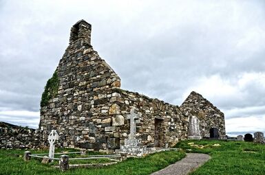
Clondahorkey Old Church, Kill, Dunfanaghy
On a hill outside Dunfanaghy sits this old church ruin and graveyard.  From Buildings of Ireland: "This attractive and poignant site is an interesting addition to the rural landscape to the south of Dunfanaghy. The simple rubble stone single-cell church, which probably originally dates to the sixteenth century and was described by a Royal Commission Report in 1622 as ‘newly re-edified and well repaired’, which suggests works here shortly prior to this date. It was originally in use as a Catholic church but was later in use as a Church of Ireland church from c. 1690 until the construction of the fine new church (see 40902615), St. John’s, at nearby Ballymore in 1752; it was abandoned shortly after this date and is depicted as ‘Church Ruins’ on the Taylor and Skinner map of the area, 1777-83, and as ‘Church (in ruins)’ on the Ordnance Survey first edition six-inch map of c. 1837. It is likely that this church was altered at some stage post 1700 ..."

email: WeLoveDonegal@gmail.com or via our CONTACT form

  • HOME
  • DONEGAL
    • DONEGAL FACTS
    • Towns & Villages of Donegal
    • Donegal ISLANDS
    • DONEGAL CHURCHES & GRAVEYARDS
    • HISTORICAL DONEGAL
    • SCHOOLS National
    • DONEGAL MASS ROCKS
    • FAMINE PLACES DONEGAL
    • OLD POSTCARDS OF DONEGAL
    • THINGS TO DO IN DONEGAL
  • BLOG
  • MORE
    • IRISH SONG WORDS
    • ALL THINGS IRISH
    • IRISH BABY NAMES
    • GALLERY
    • WW1 & WW2 GRAVES IN DONEGAL
    • LINKS
    • CONTACT
  • HOLY WELLS OF DONEGAL
    • Bruckless St. Conall's
    • Doochary St. Sarah's Well
    • FANAD Carryblagh St. Colmcilles Well
    • INISHOWEN Grianan St. Patrick's Well
  • DONEGAL VIDEOS