• HOME
  • DONEGAL
    • DONEGAL FACTS
    • Towns & Villages of Donegal
    • Donegal ISLANDS
    • DONEGAL CHURCHES & GRAVEYARDS
    • HISTORICAL DONEGAL
    • SCHOOLS National
    • DONEGAL MASS ROCKS
    • FAMINE PLACES DONEGAL
    • OLD POSTCARDS OF DONEGAL
    • THINGS TO DO IN DONEGAL
  • BLOG
  • MORE
    • IRISH SONG WORDS
    • ALL THINGS IRISH
    • IRISH BABY NAMES
    • GALLERY
    • WW1 & WW2 GRAVES IN DONEGAL
    • LINKS
    • CONTACT
  • HOLY WELLS OF DONEGAL
    • Bruckless St. Conall's
    • Doochary St. Sarah's Well
    • FANAD Carryblagh St. Colmcilles Well
    • INISHOWEN Grianan St. Patrick's Well
  • DONEGAL VIDEOS
  • WeLoveDonegal Zoom Chats
We Love Donegal
  • HOME
  • DONEGAL
    • DONEGAL FACTS
    • Towns & Villages of Donegal
    • Donegal ISLANDS
    • DONEGAL CHURCHES & GRAVEYARDS
    • HISTORICAL DONEGAL
    • SCHOOLS National
    • DONEGAL MASS ROCKS
    • FAMINE PLACES DONEGAL
    • OLD POSTCARDS OF DONEGAL
    • THINGS TO DO IN DONEGAL
  • BLOG
  • MORE
    • IRISH SONG WORDS
    • ALL THINGS IRISH
    • IRISH BABY NAMES
    • GALLERY
    • WW1 & WW2 GRAVES IN DONEGAL
    • LINKS
    • CONTACT
  • HOLY WELLS OF DONEGAL
    • Bruckless St. Conall's
    • Doochary St. Sarah's Well
    • FANAD Carryblagh St. Colmcilles Well
    • INISHOWEN Grianan St. Patrick's Well
  • DONEGAL VIDEOS
  • WeLoveDonegal Zoom Chats

DONEGAL ISLANDS ~ Rathlin O'Birne

Picture
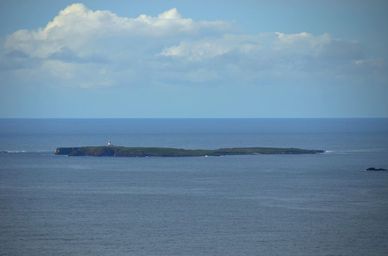
Rahlin O'Birne Island
Rathlin O'Birne Island lies off the coast line of the cliffs at Sliabh Liag (Slieve League).  It is a small, uninhabitted island and marks County Donegal's most westerly point.

The lighthouse on the island was the first nuclear powered lighthouse in Ireland and thought to be the most powerful at the time.  Wind power replaced nuclear power and this was later replaced in the early '90s by solar power.

It was to this island that St. Asicus, St. Patrick's coppersmith and the first Bishop of Elfin went and lived as a hermit for seven years.

Rathlin O'Birne Island as seen from Sliabh Liag

Picture
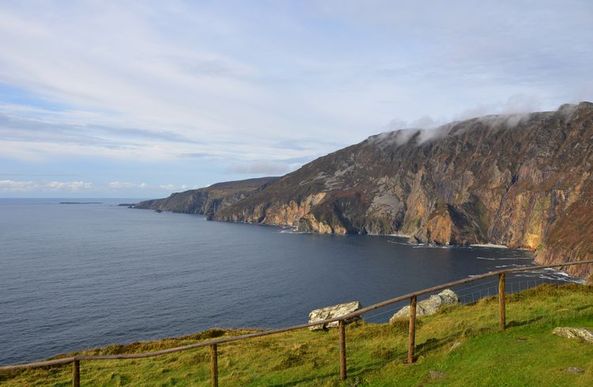
This photograph shows Rathlin O'Birne Island from nearly 2,000 feet above on the cliffs at Sliabh Liag (Slieve League) which is probably the closest most of us will get to the island.

The island is the tiny dark strip of land to the left of the tip of cliffs near the horizon.

email: WeLoveDonegal@gmail.com or via our CONTACT form

  • HOME
  • DONEGAL
    • DONEGAL FACTS
    • Towns & Villages of Donegal
    • Donegal ISLANDS
    • DONEGAL CHURCHES & GRAVEYARDS
    • HISTORICAL DONEGAL
    • SCHOOLS National
    • DONEGAL MASS ROCKS
    • FAMINE PLACES DONEGAL
    • OLD POSTCARDS OF DONEGAL
    • THINGS TO DO IN DONEGAL
  • BLOG
  • MORE
    • IRISH SONG WORDS
    • ALL THINGS IRISH
    • IRISH BABY NAMES
    • GALLERY
    • WW1 & WW2 GRAVES IN DONEGAL
    • LINKS
    • CONTACT
  • HOLY WELLS OF DONEGAL
    • Bruckless St. Conall's
    • Doochary St. Sarah's Well
    • FANAD Carryblagh St. Colmcilles Well
    • INISHOWEN Grianan St. Patrick's Well
  • DONEGAL VIDEOS
  • WeLoveDonegal Zoom Chats